Layer boundaries with confidence level
How one borehole and several CPTs become a geotechnical cross-section – and how the sheet shows which boundary is confirmed and which is adopted.
At a glance
- Purpose
- Geotechnical cross-section per site, e.g. beneath a wind turbine foundation.
- Input
- Borehole log of a key borehole (soil type, soil group, origin, carbonate content); raw CPT data qc, fs; collar elevations with source and accuracy.
- Output
- One A4 landscape sheet per site: section at true spacing, confidence level per boundary, legend, site plan.
- Calculation
- Reproducible: same input, same boundaries. Thresholds (in-house, not standardised) are stated on the sheet.
- Limitations
- Without a difference in strength or material behaviour, a boundary stays invisible in the CPT. Below the borehole, only the position of a boundary is confirmed, not the soil type.
- Standards
- DIN EN ISO 22476-1, DIN EN ISO 14688-1, DIN 18196, DIN EN 1997-2, DIN 4020
01Procedure
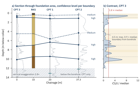
- Reference boundaries from the borehole. The borehole log gives the depth and content of each boundary.
- Contrast per CPT. Step in log qc and in the modified SBT index IB across a 0.50 m window, Eq. (1).
- Assign. Search window ±0.25·z (0.30 to 1.50 m); accepted from 1.8 times the median, top down and monotonic.
- Set the confidence level per Table 1 and draw it as line style in the section.
- Below the borehole only maxima above 2.5 times the median, spacing ≥ 1.0 m, as a short mark without correlation.
- Final check. Every borehole boundary visible, elevations with source, exaggeration stated, one sheet per site.
⟨ ⟩o, ⟨ ⟩u mean over 0.50 m above and below z · Qtn normalised cone resistance · F normalised friction ratio [%] · IB modified SBT index [4], clay-like below 22, sand-like above 32 · weighting 1/40 and thresholds 1.8 and 2.5 are in-house method parameters. IB complements log qc where material behaviour changes but strength hardly does. Beneath CPT 1, qc alone separates the layers (sand 5–10 MPa, glacial till 25.5 MPa); IB classes the till as sand-like (approx. 85) – only the borehole settles the soil type.
02Confidence level
| Level | Condition | Line | Example |
|---|---|---|---|
| high | detected in all CPTs | 1.0 · 7.0 · 9.5 m | |
| medium | partly detected, otherwise from the borehole | 0.4 · 4.5 m | |
| low | detected in none | – |
Table 1. Levels and result at the site in Figure 1; depths of the borehole boundaries.
03What the check reports
- Map vs borehole: map shows ground moraine, borehole meltwater sand to 7.0 m – flagged as a discrepancy.
- Boundary without contrast: at 4.5 m, CPT 3 reaches only 0.9 times the median. It remains visible as a borehole boundary.
- Foundation level: not drawn without a confirmed working platform elevation.
- Elevations: from the terrain model, ±0.15 m, marked as not surveyed.
- DIN EN ISO 22476-1:2023-04 Felduntersuchungen – Teil 1: Drucksondierungen mit elektrischen Messwertaufnehmern
- DIN EN ISO 14688-1:2020-11 Benennung und Beschreibung von Boden · DIN 18196:2023-02 Bodenklassifikation für bautechnische Zwecke
- DIN EN 1997-2:2010-10 Eurocode 7 – Erkundung und Untersuchung des Baugrunds · DIN 4020:2010-12 Geotechnische Untersuchungen für bautechnische Zwecke
- Robertson, P. K. (2016) Cone penetration test (CPT)-based soil behaviour type (SBT) classification system – an update. Canadian Geotechnical Journal 53, 1910–1927. doi:10.1139/cgj-2016-0044, accessed 24 Sept. 2026
SUGGESTED CITATION: GeoStudys Consulting (2026): Layer boundaries with confidence level. GeoStudys Method sheets, Sheet M01. www.geostudys.com/en/technical-articles/layer-boundaries-confidence-level.html