Plausibility check of borehole logs
Why every field entry is checked before it becomes a log, a section or a calculation.
At a glance
- Purpose
- Find errors from field logging and transcription before they propagate into annexes, sections and calculations.
- Input
- Input workbook per project: header data (drilling date, final depth, collar elevation, groundwater), layer rows, blow counts of the dynamic probing.
- Output
- One internal check page per exploratory point, based on fixed rules. The annex sheet goes to the client only once all issues are resolved.
- Limitations
- The check finds contradictions, not an internally consistent misdescription. Whether a silt is a silt is decided by field description and laboratory.
- Standards
- DIN EN ISO 14688-1 and -2, DIN EN ISO 22475-1, DIN EN ISO 22476-2, DIN 18196, DIN 4023
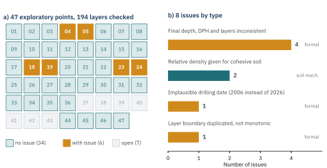
01Three check levels
| Level | What is checked | Example from Figure 1 | How |
|---|---|---|---|
| formal | Layer boundaries monotonic and without gaps; final depth equals base of last layer; end of dynamic probing consistent with final depth; drilling date plausible; collar elevation present; no duplicate sample numbers | Drilling date 31.08.2006 instead of 2026 | automatic |
| soil-mechanical | Consistency only for cohesive, relative density only for non-cohesive groups; for SU*, ST*, GU*, GT* the field description decides; soil group valid to DIN 18196; house rule: topsoil OH mostly loose, deviation flagged | “loose” for silt UL | automatic |
| against geodata | Glacial till “carbonate-free” → check decalcified zone; collar elevations against DTM1; borehole against geological map | Collar elevations within DTM1 accuracy (≤ ±0.3 m) | partly automatic, partly during processing |
zE final depth per header data · zn base of last layer · zDPH end of dynamic probing. Tolerances are in-house check rules, not values from standards; exceeding them triggers a flag, not a silent correction.
02What the check found
- Drilling date 2006: not visible in any drawing – every log would have carried a wrong date.
- Borehole 12 m, probing 8 m: two exploratory points were taken deeper than planned. Without the flag, the extra work would have gone unnoticed.
- Layer row at 2.80 m appended to a 6 m borehole: a transcription leftover that would have reversed the sequence of strata.
- Final depth 4.0 m, layers to 6.0 m: header data and log disagree; resolved from the field record, not at the desk.
03Where the check sits
The check page is generated as the second page of every annex sheet and is dropped only on delivery. The input workbook accepts only genuine date values; on locking, formulas are replaced by values so that no link to another workbook remains.
Only checked borehole logs go into the geotechnical cross-section with confidence level [3] and into the calculations.
- DIN EN ISO 14688-1 and -2:2020-11 Benennung, Beschreibung und Klassifizierung von Boden · DIN 18196:2023-02 Bodenklassifikation für bautechnische Zwecke
- DIN EN ISO 22475-1:2022-02 Probenentnahme · DIN EN ISO 22476-2:2012-03 Rammsondierungen · DIN 4023:2023-02 Zeichnerische Darstellung der Ergebnisse von Bohrungen
- GeoStudys Method sheet 01 (2026) Layer boundaries with confidence level
SUGGESTED CITATION: GeoStudys Consulting (2026): Plausibility check of borehole logs. GeoStudys Method sheets, Sheet M02. www.geostudys.com/en/technical-articles/borehole-log-plausibility-check.html