Ground risk before investment
What a feasibility study can deliver from existing data – two cases from the energy sector
Large energy projects are approved before the ground is investigated. A feasibility study constrains the ground risk first: it merges existing geodata and runs automated checks for contradictions. Two cases – a battery energy storage system (BESS) in the uplands and a cable route in ground moraine – show which findings drive costs and how they yield a targeted investigation programme.
KEYWORDS · Feasibility study · Ground risk · Data fusion · Plausibility check · Dead ice
1Background
Sites and routes are chosen before any rig is on site. DIN 4020 defines ground risk as the risk remaining even after investigation to accepted practice [2] – which includes evaluating existing data. DIN EN 1997-2 requires existing information to be reviewed before investigation [1]. Contractual risk allocation depends on the case and the specification [5], [6]: what the client knows and describes about the ground partly decides what it pays later.
2Data fusion and plausibility check
The study combines geological map, DTM1, aerial photos, biotope and mining registers, existing boreholes and plans in one spatial reference. The automated check looks for contradictions: do the collar elevations match the DTM1? Is the ground between two exploratory points lower than both? Each finding enters a risk register with its cost impact and investigation target (Table 1).
3Case A: BESS in the uplands
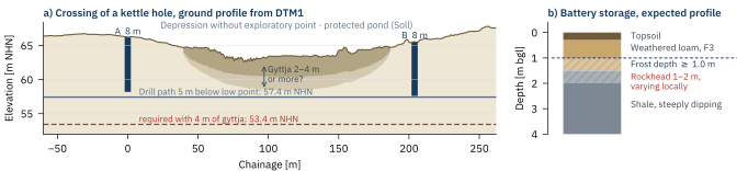
Planned: 16 containers of approx. 43 t each on approx. 1.2 ha. The DTM1 resolved conflicting elevations: valley floor, not plateau – with solifluction deposits and perched water. Below F3 loam lies Devonian shale at 1 to 2 m depth, varying over short distances (Figure 1b). Consequences: excavation mostly by ripper, locally by breaker; mixed foundation; soil replacement and drainage instead of infiltration. Eight RKS and eight DPH target the rockhead.
4Case B: underground cable route in ground moraine
On a 33 kV route, the ground profile from the DTM1 was computed between each pair of exploratory points. At a track crossing listed as non-critical lay a depression 148 m wide and 3.8 m deep with no exploratory point (Figure 1a): a protected Soll, i.e. a kettle hole, filled with gyttja and peat [3], [4]. The path is governed by the base of the soft layers:
zA path · HT lowest point · dW soft layers · ü cover in competent soil, here set at 5.0 m (cf. [7]) · DB borehole diameter
With 4 m of gyttja, only 1.0 m of competent soil would remain above the path; more gyttja cannot be ruled out. Both exploratory holes end at 8 m, above the path; approx. 9 to 13 m or more would be needed [7]. A hand auger at the margin shows whether and how far soft layers extend; their thickness at the deepest point can only be established by a probe in the depression, with the consent of the nature conservation authority. Resistivity surveys are of limited use where contrast is low.
| Finding | Cost impact | Investigation target |
|---|---|---|
| A · Rock 1–2 m | Ripper, mixed foundation | Rockhead |
| A · Valley floor | F3, perched water, drainage | Water levels, grading |
| B · Depression | Deeper path, longer crossing | Base of gyttja |
| B · Soll | protected, no drilling rig | Margin; deepest point with authority |
5Outcome for the investor
A risk register with cost impacts before the site or route is fixed, and an investigation programme for each finding – no substitute for the ground investigation. In case B, additional drilling fell from nine exploratory points totalling 100.5 m to three totalling 30 m.
- DIN EN 1997-2:2010-10 Sections 2.1.1 and 2.3
- DIN 4020:2010-12 Geotechnische Untersuchungen für bautechnische Zwecke
- BNatSchG § 30(2) No. 1 – statutorily protected biotopes
- BbgBiotopSchV No. 1.2 – small water bodies, Sölle
- Römer, V. (2022) Baugrund – wer trägt das Risiko? Straße und Autobahn 1/2022
- BGH judgment of 20 Aug. 2009 – VII ZR 205/07
- GeoStudys Technical articles 1 (2026) Investigation depth for HDD crossings
SUGGESTED CITATION: GeoStudys Consulting (2026): Ground risk before investment. GeoStudys Technical articles, Issue 1, Article 05. www.geostudys.com/en/technical-articles/ground-risk-before-investment.html